National Register of Historic Places listings in Niagara Falls, New York
This is a list of the National Register of Historic Places listings in Niagara Falls, New York.
This is intended to be a complete list of the properties and districts on the National Register of Historic Places in Niagara Falls, New York, United States. The locations of National Register properties and districts for which the latitude and longitude coordinates are included below, may be seen in a map.[1]
There are 82 properties and districts listed on the National Register in Niagara County. The city of Niagara Falls is the location of 29 of these properties and districts; they are listed here, while the remaining 53 properties and districts are listed separately.
- This National Park Service list is complete through NPS recent listings posted December 16, 2016.[2]
| Albany (Albany) – Allegany – Bronx – Broome – Cattaraugus – Cayuga – Chautauqua – Chemung – Chenango – Clinton – Columbia – Cortland – Delaware – Dutchess (Poughkeepsie, Rhinebeck) – Erie (Buffalo) – Essex – Franklin – Fulton – Genesee – Greene – Hamilton – Herkimer – Jefferson – Kings – Lewis – Livingston – Madison – Monroe (Rochester) – Montgomery – Nassau – New York (Below 14th Street, 14th to 59th Streets, 59th to 110th Streets, Above 110th Street, Islands) – Niagara – Oneida – Onondaga (Syracuse) – Ontario – Orange – Orleans – Oswego – Otsego – Putnam – Queens – Rensselaer – Richmond – Rockland – St. Lawrence – Saratoga – Schenectady – Schoharie – Schuyler – Seneca – Steuben – Suffolk – Sullivan – Tioga – Tompkins – Ulster – Warren – Washington – Wayne – Westchester (Northern, Southern, New Rochelle, Peekskill, Yonkers) – Wyoming – Yates |
Listings city-wide
Legend: National Register of Historic Places listing National Historic Landmark Historic district National Historic Landmark District
| [3] | Name on the Register | Image | Date listed[4] | Location | City or town | Description |
|---|---|---|---|---|---|---|
| 1 | Adams Power Plant Transformer House | 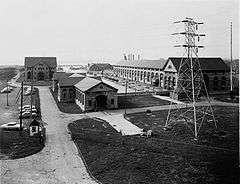 |
(#75001212) |
Buffalo Ave. near Portage Rd. 43°04′54″N 79°02′34″W / 43.081667°N 79.042778°W |
Niagara Falls | McKim, Mead, and White designed structure from the first alternating current electric generating plant in the world; constructed in 1895. |
| 2 | Chilton Avenue-Orchard Parkway Historic District | 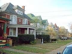 |
(#10000771) |
Portions of Chilton Avenue and Orchard Parkway 43°06′02″N 79°03′17″W / 43.100556°N 79.054722°W |
Niagara Falls | |
| 3 | Deveaux School Historic District | 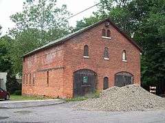 |
(#74001281) |
2900 Lewiston Rd. 43°07′N 79°04′W / 43.12°N 79.06°W |
Niagara Falls | Campus of school for impoverished boys; later boys prep school. |
| 4 | First Presbyterian Church | 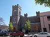 |
(#14000145) |
311 1st St., Rainbow Blvd., N. 43°05′12″N 79°03′41″W / 43.08664°N 79.061353°W |
Niagara Falls | |
| 5 | First Presbyterian Manse | 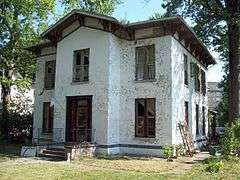 |
(#12000367) |
162 Buffalo Ave. 43°04′59″N 79°03′36″W / 43.083162°N 79.059943°W |
Niagara Falls | |
| 6 | First Unitarian Universalist Church of Niagara | 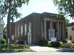 |
(#06001301) |
639 Main St. 43°05′44″N 79°03′24″W / 43.095556°N 79.056667°W |
Niagara Falls | Classical Revival style constructed in 1921-1922. |
| 7 | Former Niagara Falls High School | 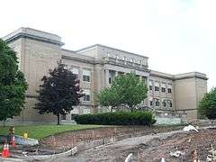 |
(#01001507) |
1201 Pine Ave. 43°05′36″N 79°02′08″W / 43.093333°N 79.035556°W |
Niagara Falls | High school built in 1923-1924; now community arts center. |
| 8 | Holley-Rankine House | 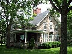 |
(#79003793) |
525 Riverside Dr. 43°04′53″N 79°03′20″W / 43.081389°N 79.055556°W |
Niagara Falls | Gothic Revival cottage built about 1855; now operated as a bed and breakfast. |
| 9 | Holy Trinity Roman Catholic Church Complex | 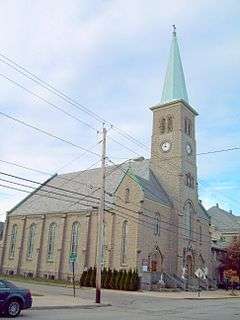 |
(#10000334) |
1419 Falls St. 43°05′13″N 79°02′39″W / 43.086944°N 79.044167°W |
Niagara Falls | |
| 10 | Jefferson Apartment Building | 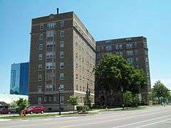 |
(#04001452) |
250 Rainbow Blvd. 43°05′10″N 79°03′33″W / 43.086111°N 79.059167°W |
Niagara Falls | Eight story brick apartment building constructed in 1926. |
| 11 | Mount St. Mary's Hospital | 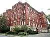 |
(#15000922) |
515 6th St. Coordinates missing |
Niagara Falls | Early 20th century building reflects growing Catholic immigrant population |
| 12 | The Niagara | 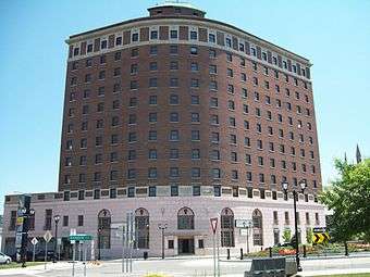 |
(#08001145) |
201 Rainbow Blvd. 43°05′06″N 79°03′40″W / 43.085°N 79.061111°W |
Niagara Falls | Former hotel building. |
| 13 | Niagara Falls Armory | 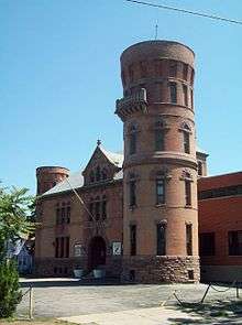 |
(#95000076) |
901 Main St. 43°05′51″N 79°03′14″W / 43.0975°N 79.053889°W |
Niagara Falls | Castellated armory building constructed in 1895; part of the Multiple Property Submission for Army National Guard Armories in New York State. |
| 14 | Niagara Falls City Hall | 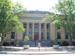 |
(#00001688) |
745 Main St. 43°05′45″N 79°03′19″W / 43.095833°N 79.055278°W |
Niagara Falls | Beaux-Arts style municipal building constructed in 1923-1924. |
| 15 | Niagara Falls Public Library | 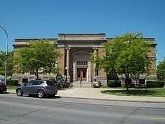 |
(#74001282) |
1022 Main St. 43°05′56″N 79°03′16″W / 43.098889°N 79.054444°W |
Niagara Falls | Philanthropist Andrew Carnegie funded library constructed in 1902-1904; now city offices. |
| 16 | Niagara Falls School District Administration Building | 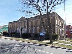 |
(#14001020) |
607 Walnut St. 43°05′34″N 79°03′19″W / 43.092678°N 79.055262°W |
Niagara Falls | 1928 Classical Revival building constructed when two village school districts were merged into one city district |
| 17 | Niagara Reservation | 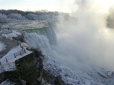 |
(#66000555) |
Niagara Reservation 43°04′54″N 79°03′55″W / 43.081667°N 79.065278°W |
Niagara Falls | Oldest state park in the United States, established in 1885. |
| 18 | Oakwood Cemetery | 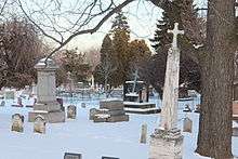 |
(#14000581) |
763 Portage Rd. 43°05′49″N 79°03′00″W / 43.0968222°N 79.0501346°W |
Niagara Falls | 1852 cemetery has special section for people who went over the falls in a barrel |
| 19 | Park Place Historic District | 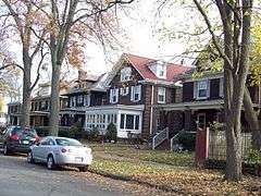 |
(#10000809) |
Park Place, portions of Prince Ave., 4th St., and Main St. 43°05′44″N 79°03′25″W / 43.095556°N 79.056944°W |
Niagara Falls | |
| 20 | St. Mary's Nurses' Residence | 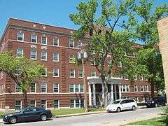 |
(#04000711) |
542 6th St. 43°05′35″N 79°03′21″W / 43.093056°N 79.055833°W |
Niagara Falls | Brick residence hall constructed in 1928. |
| 21 | Schoellkopf Power Station No . 3 Site | 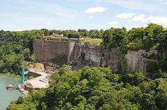 |
(#13000029) |
East bank of Niagara River; 1,600 feet (490 m) downriver from Rainbow Bridge 43°05′36″N 79°03′44″W / 43.09343°N 79.062128°W |
Niagara Falls | Stone wall is most visible remnant of power plant whose 1956 collapse into the river cleared the way for development of Niagara Power Project, considered culmination of effort to put utilities in public hands. |
| 22 | Hazard H. Sheldon House | 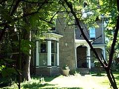 |
(#11000275) |
539 4th St. 43°05′31″N 79°03′28″W / 43.091944°N 79.057778°W |
Niagara Falls | Italian Villa style stone dwelling built about 1857. |
| 23 | Town of Niagara District School No. 2 | 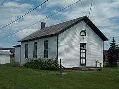 |
(#05000021) |
9670 Lockport Rd. 43°07′18″N 78°57′03″W / 43.121667°N 78.950833°W |
Niagara Falls | One room school built in 1878. |
| 24 | U.S. Customhouse (Niagara Falls) | 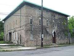 |
(#73001227) |
2245 Whirlpool St. 43°06′35″N 79°03′21″W / 43.109722°N 79.055833°W |
Niagara Falls | Stone customhouse constructed in 1863. |
| 25 | United Office Building | 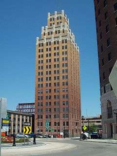 |
(#05001537) |
220 Rainbow Blvd. 43°05′14″N 79°03′45″W / 43.087222°N 79.0625°W |
Niagara Falls | Art deco 20 story skyscraper completed in 1929. |
| 26 | US Post Office-Niagara Falls Main | 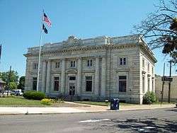 |
(#88002379) |
Main and Walnut Sts. 43°05′34″N 79°03′25″W / 43.092778°N 79.056944°W |
Niagara Falls | Post office built in 1904-1907; part of the Multiple Property Submission for the US Post Offices in New York State, 1858-1943. |
| 27 | Whitney Mansion | 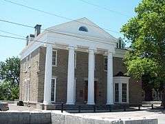 |
(#74001283) |
335 Buffalo Ave. 43°04′54″N 79°03′31″W / 43.081667°N 79.058611°W |
Niagara Falls | Two story Greek Revival stone structure built in 1849. |
| 28 | Johann Williams Farm |  |
(#80002730) |
10831 Cayuga Dr. 43°05′29″N 78°56′36″W / 43.091389°N 78.943333°W |
Niagara Falls | Farmhouse and related outbuildings dating to 1840s. |
See also
| Wikimedia Commons has media related to National Register of Historic Places in Niagara Falls, New York. |
- National Register of Historic Places listings in New York
- List of National Historic Landmarks in New York
References
- ↑ The latitude and longitude information provided in this table was derived originally from the National Register Information System, which has been found to be fairly accurate for about 99% of listings. For about 1% of NRIS original coordinates, experience has shown that one or both coordinates are typos or otherwise extremely far off; some corrections may have been made. A more subtle problem causes many locations to be off by up to 150 yards, depending on location in the country: most NRIS coordinates were derived from tracing out latitude and longitudes off of USGS topographical quadrant maps created under the North American Datum of 1927, which differs from the current, highly accurate WGS84 GPS system used by most on-line maps. Chicago is about right, but NRIS longitudes in Washington are higher by about 4.5 seconds, and are lower by about 2.0 seconds in Maine. Latitudes differ by about 1.0 second in Florida. Some locations in this table may have been corrected to current GPS standards.
- ↑ "National Register of Historic Places: Weekly List Actions". National Park Service, United States Department of the Interior. Retrieved on December 16, 2016.
- ↑ Numbers represent an ordering by significant words. Various colorings, defined here, differentiate National Historic Landmarks and historic districts from other NRHP buildings, structures, sites or objects.
- ↑ The eight-digit number below each date is the number assigned to each location in the National Register Information System database, which can be viewed by clicking the number.
| Topics |   | |
|---|---|---|
| Lists by county |
| |
| Lists by city | ||
| Other lists | ||
| ||